Introduction:
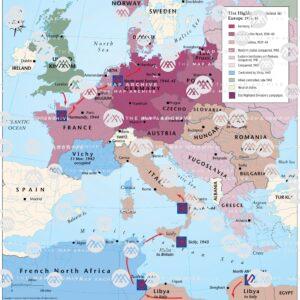
World War II, one of the most significant and devastating conflicts in human history, unfolded on a global scale, reshaping political boundaries and altering the course of nations. Within this global theater, the European front emerged as a critical battleground, witnessing the clash of ideologies, the resilience of nations, and the sacrifice of millions. To truly understand the dynamics of World War II in Europe, it is essential to delve into the intricacies of the European World War II map, a document that tells the tale of conquest, resistance, and liberation.
The Early Stages:
As the storm clouds of war gathered over Europe in the late 1930s, the geopolitical landscape began to shift dramatically. Germany, under the leadership of Adolf Hitler, sought to expand its influence and territorial control, setting in motion a series of events that would lead to the outbreak of World War II. The invasion of Poland in September 1939 marked the beginning of hostilities and triggered a domino effect of conflict across the continent.
The European World War II map of the early stages reflects the rapid expansion of German forces, showcasing the Blitzkrieg tactics that allowed them to swiftly overcome Poland, Denmark, Norway, the Low Countries, and France. This period of German dominance saw the establishment of puppet governments in conquered territories and the erection of the infamous Iron Curtain.
Eastern Front:
A significant portion of the European World War II map was dominated by the Eastern Front, where the German military engaged in a brutal campaign against the Soviet Union. Operation Barbarossa, launched in June 1941, aimed to crush the Soviet regime and secure Lebensraum (living space) for the expanding German population. The vast expanse of the Eastern Front witnessed some of the deadliest battles in history, such as Stalingrad and Kursk.
As the Soviet Union gradually turned the tide, pushing the German forces back, the European World War II map evolved to reflect the changing fortunes of war. The Red Army's relentless advance through Eastern Europe marked a turning point in the conflict, showcasing the resilience of the Soviet people and their determination to repel the invaders.
Western Front:
Simultaneously, the Western Front became a focal point of the Allied efforts to liberate Europe from Nazi occupation. The D-Day landings on June 6, 1944, marked a historic turning point, as Allied forces landed on the beaches of Normandy, establishing a crucial foothold in Western Europe. The European World War II map, at this juncture, illustrates the Allied push through France, Belgium, and the Netherlands, as they sought to liberate territories and push the German forces back.
The Battle of the Bulge, a last-ditch German offensive in the Ardennes, tested the resilience of the Allied forces but ultimately failed to alter the course of the war. The European World War II map reflects the gradual encirclement of German forces, leading to the final stages of the conflict in the West.
Liberation and Occupation:
As the Allies advanced, liberating cities and nations from Nazi occupation, the European World War II map transformed from a canvas of conquest to one of liberation. The fall of Berlin in May 1945 marked the symbolic end of the war in Europe, and the map showcased the victorious Allied powers and the division of Germany into East and West.
The aftermath of World War II saw the emergence of a new geopolitical order, with the establishment of the United Nations and the onset of the Cold War between the United States and the Soviet Union. The European World War II map reflected the new boundaries, with Eastern Europe falling under Soviet influence and the formation of the Iron Curtain.
Legacy and Remembrance:
The European World War II map not only serves as a historical document but also stands as a testament to the human cost of war and the resilience of nations. The scars of conflict lingered long after the war's end, as Europe embarked on a path of reconstruction and reconciliation. The map, with its markings of battles and strategic maneuvers, serves as a reminder of the sacrifices made by millions and the importance of safeguarding peace and stability.
Today, as we reflect on the European Theater of World War II, the map serves as a tool for understanding the complexities of the conflict. It allows us to trace the footsteps of soldiers, comprehend the strategies of military leaders, and appreciate the interconnectedness of nations during this turbulent period. The European World War II map encapsulates a chapter in history that shaped the world we live in today, emphasizing the importance of learning from the past to build a more peaceful future.
Conclusion:
In the annals of history, the European World War II map stands as a visual narrative of a continent torn by conflict and ultimately united in its determination to overcome tyranny. From the early stages of German expansion to the liberation of occupied territories, the map documents the ebb and flow of a war that reshaped the geopolitical landscape of Europe. As we mark the 1-year anniversary of this pivotal moment in history, let us remember the lessons embedded in the lines and symbols of the European World War II map, ensuring that the sacrifices of the past guide us toward a future of peace and understanding.


Comments