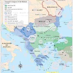
The Ottoman Empire, once a dominant force that spanned three continents, has left an indelible mark on history. Understanding its vast expanse through maps helps to appreciate the sheer size and influence of this empire. From its humble beginnings in the late 13th century to its peak in the 16th and 17th centuries, and its eventual dissolution after World War I, the Ottoman Empire's evolution can be traced through historical maps.
The Birth and Early Expansion of the Ottoman Empire
The Ottoman Empire Map began in 1299 when Osman I declared independence from the Seljuk Turks. Situated in Northwestern Anatolia, modern-day Turkey, the Ottomans initially controlled a small territory. However, through strategic marriages, alliances, and military conquests, they quickly expanded.
By the 14th century, the Ottomans had crossed into Europe, conquering parts of the Balkans. The capture of Constantinople (modern-day Istanbul) in 1453 by Sultan Mehmed II marked a significant turning point. This conquest not only solidified the Ottoman control over the Byzantine capital but also positioned the empire as a central power between Europe and Asia.
The Zenith: The Ottoman Empire at Its Peak
At its height during the 16th and 17th centuries, under the reigns of Suleiman the Magnificent and his predecessors, the Ottoman Empire stretched from the gates of Vienna in the west to the Persian Gulf in the east, and from the steppes of Ukraine in the north to the sands of Arabia and the coasts of North Africa in the south.
Europe and the Balkans
In Europe, the Ottomans controlled large portions of the Balkans, including present-day Greece, Bulgaria, Serbia, Bosnia and Herzegovina, and parts of Hungary and Romania. The conquest of these territories provided the Ottomans with significant strategic and economic advantages, securing key trade routes and resources.
Anatolia and the Middle East
Anatolia, the heartland of the Ottoman Empire, remained a stronghold throughout its history. The empire's influence extended into the Middle East, encompassing modern-day Iraq, Syria, Lebanon, Israel, Palestine, and parts of Saudi Arabia. The control of holy cities like Mecca and Medina further solidified the Ottoman sultans' status as caliphs, leaders of the Muslim world.
North Africa
In North Africa, the Ottomans exerted control over Egypt, Libya, Tunisia, and Algeria. The conquest of Egypt in 1517 by Selim I was particularly significant as it brought the Mamluk Sultanate under Ottoman rule and gave the Ottomans access to the Red Sea and the Indian Ocean.
Mapping the Empire: Cartographic Representations
Historical maps of the Ottoman Empire vary greatly, reflecting the changing borders and administrative divisions over the centuries. These maps are invaluable tools for historians and enthusiasts, providing insights into the geopolitical landscape of different eras.
Early Maps and Expansion
Early maps from the 14th and 15th centuries depict a relatively small territory centered around Northwestern Anatolia. As the empire expanded, maps from the 16th and 17th centuries began to show the vast expanse of Ottoman control, highlighting major cities, trade routes, and significant battle sites.
The Age of Exploration and Detailed Cartography
The Age of Exploration brought more detailed and accurate maps, as European cartographers sought to document the world. The Ottoman Empire featured prominently in these maps, often depicted with its distinct regions and provinces. Notable maps from this period include those by Piri Reis, an Ottoman admiral and cartographer, whose work combined local knowledge with European cartographic techniques.
Modern Interpretations
Modern maps of the Ottoman Empire provide a retrospective view, illustrating the empire's maximum territorial extent and its evolution over time. These maps often use color-coding to differentiate between core territories, vassal states, and areas of influence, offering a comprehensive overview of the empire's reach.
The Decline and Legacy of the Ottoman Empire
The decline of the Ottoman Empire began in the late 17th century, accelerated by military defeats, economic challenges, and internal strife. The empire struggled to keep pace with the rapidly modernizing European powers. The 19th century saw significant territorial losses, including the independence of Greece and the gradual loss of Balkan territories.
The final blow came with World War I. The Ottoman Empire sided with the Central Powers and faced a crushing defeat. The subsequent Treaty of Sèvres in 1920 and the Turkish War of Independence led to the establishment of the Republic of Turkey in 1923, officially ending the Ottoman Empire.
The Modern Ottoman Empire Map: A Legacy Preserved
Today, modern maps of the former Ottoman Empire serve as a testament to its historical significance. These maps are available in various forms, from detailed historical atlases to interactive online platforms. They not only highlight the empire's vast territorial reach but also its cultural and political influence.
The Map Archive
One of the most comprehensive resources for Ottoman Empire maps is the Map Archive. This digital repository offers a wide range of maps, from early hand-drawn illustrations to detailed modern recreations. The archive provides access to the biggest and most detailed maps of the Ottoman Empire, allowing users to explore its extensive history and geographical breadth.
Conclusion
The Ottoman Empire, with its rich history and expansive territory, remains a subject of fascination for historians and map enthusiasts alike. From its rise in Anatolia to its dominance across three continents, the empire's story is intricately linked to its geography. Maps serve as a window into this past, offering a visual representation of the empire's growth, zenith, and eventual decline. The modern map archives preserve this legacy, ensuring that the story of the Ottoman Empire continues to be explored and appreciated for generations to come.


Comments